Outdoor News Bulletin
Inventorying a National Treasure - Oxbow Lakes in the Lower Mississippi Valley
It has been estimated that the Lower Mississippi Alluvial Valley includes roughly 1,500 floodplain lakes that represent the largest concentration of oxbow lakes in North America. Water quality and environmental degradation are the primary concern in most of these lakes, stemming from disturbances associated with agriculture, regulation of discharges from major flood-control reservoirs, and stream channelization. To support restoration efforts, the Mississippi Cooperative Fish and Wildlife Research Unit is leading research on water quality and fish assemblages to inform various state and federal agencies with jurisdiction over the alluvial valley.
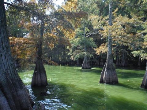
The alluvial valley of the lower Mississippi River contains hundreds of lakes formed as a result of channel meandering, braiding, and associated processes. These lakes vary in age from about 50 to over 10,000 years old and represent abandoned channels of contemporary rivers as well as those of prehistoric rivers that once occupied the valley.
These lakes exhibit a broad range of environmental characteristics that sustains an important component of North American biodiversity and provides key ecological services. Nearly 50 species of mammals, 60 percent of all bird species in the contiguous U.S., 45 species of reptiles and amphibians, and 37 species of mussel occupy the valley. Additionally, 136 species of fish depend on the river and floodplain system, and nearly 100 fish species have been documented in oxbow lakes and backwaters.
Ecological services provided by these lakes include greenhouse gas mitigation, nitrogen mitigation, and recreation. It has been estimated that restoration and maintenance of wetlands and oxbow lakes in the valley could have a social value larger than agricultural use. Nevertheless, it is unknown exactly how many of these lakes exist, their distribution, and their physical characteristics relative to existing landscape features. Estimation is complicated because it is difficult to determine when a lake ceases to be a lake and becomes a wetland. The lack of a lake inventory is a major challenge to conservation, restoration, and management of oxbow lakes. Without such an inventory, it is difficult to impress to conservation agencies and the public how prevalent and important these lakes are. Thus, Mike Rhodes, a student with the Mississippi Unit is using remotely-sensed imagery to inventory the entire lower Mississippi Alluvial Valley from Cairo, Illinois to Baton Rouge, Louisiana.
Landsat satellites have compiled a library of images that document changing landscapes and environmental conditions with repeat observations over the same location every 16 days (not all Landsat scenes are usable because of cloud cover). For each Landsat image available from the USGS Earth Explorer website, Mike will classify each pixel as to being wet or dry, and an inundation index will be calculated for each pixel as the proportion of all images in which that pixel was classified as wet. An inundation index will be used to estimate lake connectivity to adjacent streams. Information such as lake size and shape and surrounding land use can be readily obtained from geographic information system (GIS) layers. Variables such as depth will be estimated based on extent of seasonal expansion/contraction of lake areas, extracted from the Landsat images.
The resulting inventory may be useful for a wide diversity of conservation, research, and management applications. However, perhaps its biggest contribution may be to refocus management into a broader framework. Overall abiotic and biotic diversity will be best protected by safeguarding whole sections of the valley rather than attempts at management of local-scale habitats. The inventory will help state and federal management agencies identify high quality sections to target for conservation and impacted sections in need of restoration.
The ONB features articles from Cooperative Fish and Wildlife Research Units across the country. Working with key cooperators, including WMI, Units are leading exciting, new fish and wildlife research projects that we believe our readers will appreciate reading about. This article was written by Steve Miranda, Assistant Unit Leader, Yvonne Allen an aquatic habitat analyst with USFWS, and Michael Rhodes, Master’s student. You can find more information on the Mississippi Cooperative Fish and Wildlife Research Unit website.


