Outdoor News Bulletin
NatureScape: A Landscape Conservation Design Decision-Making Tool Developed for Appalachia
The most basic question that conservation professionals often face is, “Why is this place important?” Biologists, managers, planners, researchers, and other resource professionals frequently focus on site-based issues and the determination of the relative importance of the site to achieving desired conservation objectives. However, several more complex, and often more important, questions are: “What other resources and conservation targets are also within the target and surrounding areas?” and Where do we get the most conservation ‘bang for the buck’?”
To resolve these questions, resource professionals must examine target areas as mere components of the greater geographic landscape. They must understand and evaluate future projections of land-use changes and both current and future threats at that broader perspective. This systems-level analysis, by definition, shifts focus from species and habitats to the interrelatedness of the physical and biological components required to synergistically form healthy and resilient ecosystems. This approach also requires a balance that integrates human values that ultimately influence conservation targets, actions, and outcomes. When done properly, this approach helps to answer the most important conservation question: “What is the wisest, sustainable long-term investment of our conservation efforts?”
Recently, the Appalachian Landscape Conservation Cooperative (LCC) has focused on developing a state-of-the-science, landscape decision-making tool designed to help conservation professionals optimize their investments into the most sustainable long-term conservation in Appalachia. NatureScape is a landscape conservation design decision-making tool developed to meet the needs of the Appalachian LCC partners. It takes a holistic approach to conservation planning that helps to identify and address the greater conservation objectives for land and resource management decisions for a vast region that stretches from Alabama to New York.
NatureScape was designed using the advanced, cutting-edge science of experts at Clemson University. The researchers and Appalachian LCC staff first coordinated a series of consultations with experts across Appalachia to ensure that priority species, habitats, and ecosystems were integrated into the application. These partners then worked to identify appropriate frameworks for assessing aquatic integrity, key conservation targets and threats to ecosystems, and to delve further into representative databases of the region. Researchers then used super-computing technology and Marxan software (the most widely used conservation planning tool in designing networks of terrestrial, aquatic, and marine conservation areas) to identify ecologically significant habitats and natural resources that are connected across the landscape and will be resilient to future threats.
By design, NatureScape is a suite of conservation tools to help inform intelligent decision-making at the landscape-level. It is designed to provide outputs in the form of conservation design maps that reflect cost-benefit ‘optimization’ modeling output. It also is capable of producing summary data tables that are customized to examine a specific location or region in order to visualize the data driving the modeling solution or map design. Finally, it can provide the aquatic condition scores that allow the user to visualize the aquatic or watershed influences on overall conservation design.
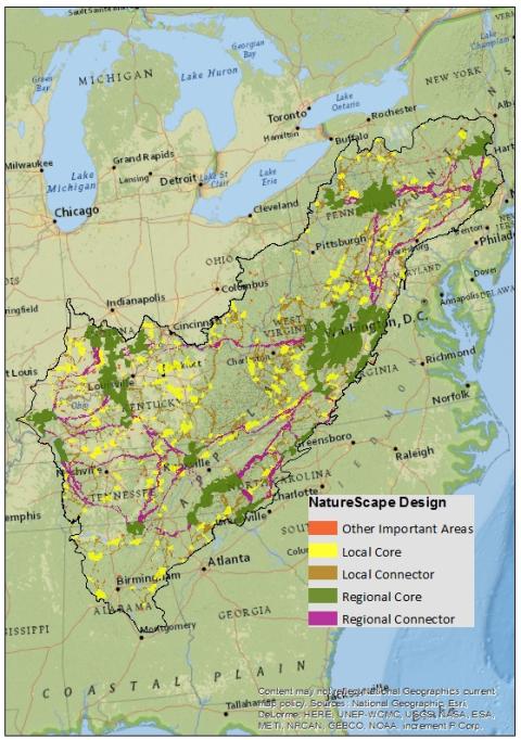
In Appalachia, NatureScape has been used to categorize potential target conservation areas into five elements that cover many ecologically significant habitats and processes across the region. These elements include:
- regional interconnected cores (broad areas of regional significance having high landscape connectivity);
- regional corridors that provide connectivity for regional cores;
- small local core areas that are likely to contain larger ecological significance than their size would suggest or that act as buffers around existing protected areas;
- small corridors that provide connectivity for local core areas; and
- other ecologically important areas present in the region
The Appalachian LCC is currently using NatureScape to incorporate and model newly developed data and information from all Appalachian LCC funded research projects as well as key existing datasets from partners to produce a series of resources (maps, tools and datasets) that integrate aquatic connectivity with significant terrestrial habitats in order to guide conservation planning and decision-making at the landscape-level. Users also have the ability to incorporate regional information and future predicted trends of a changing landscape into their own local land use and natural resource decision-making. This new innovative tool has great potential to optimize conservation decision-making throughout Appalachia by:
- Taking a holistic approach to conservation planning;
- Considering areas that may be more resilient to large-scale impacts (i.e. energy development, urbanization, changing climate factors);
- Employing a cost-benefit approach to arrive at the final design or optimal solution. Cost (fragmentation or loss of connectivity) is entered in its mathematical calculations as a ‘penalty’ applied to an investment to identify the least cost to reach the overall conservation goals;
- Integrating aquatic conditions into the modeling design that captures four key variables influencing aquatic environment (modeled at both the catchment and stream reach –level, while modifying condition based on buffer areas around each);
- Incorporating socio-economic variables (ecosystem benefits and services, carbon storage, and watershed areas important to drinking water supply) into the design; and
- Representing partnership-prioritization, reflecting programmatic interests of the diverse conservation community across an ecologically-defined landscape.
Online Training:
A self-paced, free, training course has been developed to walk end users through the suite of resources available through the Appalachian NatureScape. The course includes: videos, readings, presentations, discussions, a course quiz, and a downloadable certificate of completion.


